 |
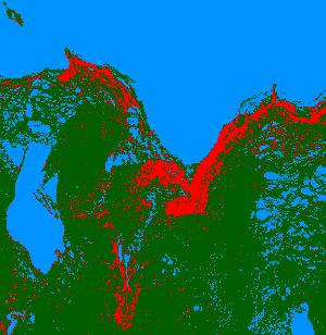
In southern Hudson and James Bays high densities of breeding snow geese are present at the Knife-Seal Rivers (Manitoba), Cape Churchill peninsula - including La Pérouse Bay (Manitoba), West Pen Islands (Ontario), Shell Brook (Ontario), Cape Henrietta Maria (Ontario), Lakitusaki-Opinnagau Rivers (Ontario) and Akimiski Island (NWT). These colonies are of different ages, different densities and show different geographical dispersion patterns over time. The use of LANDSAT imagery at near decadal intervals (1973, 1984, 1994) allows detection of long-term vegetation change particularly at colonies where densities are high or there is rapid expansion of the colony and areas with high densities of spring concentrations of migrating geese. The vegetational changes do not just include loss of vegetational cover. At some sites, sedge communities have been destroyed by geese and have been replaced by moss carpets. The latter are a poor source of forage for geese. |
Orange areas indicate habitat that has been degraded over the 20 years spanned by the composite image. |